
"Guilin and Yangshuo: The Long Scroll of Karst Scenery"
By PandaTrip Editorial · 6 min read · Verified 2026-09-06
Verified 2026-09-06

“Guilin's scenery is the finest under heaven” — a line every Chinese schoolchild grows up reciting — was written in 1201, during the Jiading era of the Southern Song dynasty, by the official Wang Zhenggong for a banquet honoring local scholars. For eight hundred years it has stood as the most enduring seal of approval ever given to one place's scenery. Guilin was on President Bill Clinton's China itinerary in 1998, and in 2014 the Guilin karst was inscribed on the UNESCO World Natural Heritage list as part of the Phase II extension of the South China Karst property. Its most widely recognized identity card, though, is printed in everyone's wallet: the back of the ¥20 banknote is the Huangbu (Yellow Cloth Shoal) reflection on the Xingping stretch of the Li River.
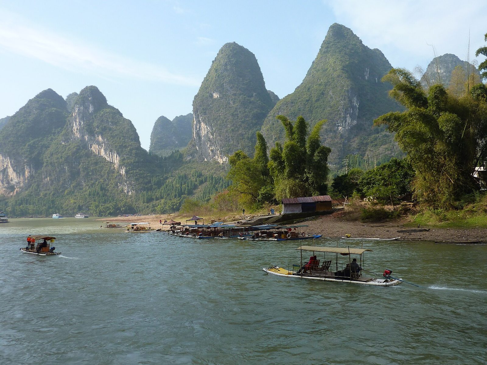
A 300-Million-Year Water Chisel: How the Karst Was Made
The scientific backstory of Guilin's scenery: about 300 million years ago this was open ocean, which deposited thousands of meters of limestone (calcium carbonate). After tectonic uplift raised it above the sea, subtropical rain combined with carbon dioxide into weak carbonic acid and spent eons dissolving the soluble limestone — cracks widened into sinkholes, sinkholes into hollows, hollows into valleys, until only clusters of tower- and cone-shaped stone peaks were left standing, with rivers meandering across the flats between them. The Li River is the main line this carving blade drew: along roughly 83 kilometers of waterway from Guilin to Yangshuo, the shifting density and form of the peaks on both banks were distilled by the ancients into four wonders — “green hills, limpid waters, marvelous caves, beautiful rocks.”
Unlike Zhangjiajie's quartz-sandstone peak forest (carved by water cutting through hard sandstone), Guilin is a karst landscape where water truly “ate” the rock away — the stalagmites and stalactites in caves such as Reed Flute Cave and Silver Cave are by-products of that dissolution, grown drop by drop over a hundred thousand years and more.
From the Lingqu Canal to the Wartime Culture City
Guilin's history is often eclipsed by the fame of its scenery, but it has real substance: in 214 BC, Qin Shi Huang had the Lingqu Canal dug for his campaign into Lingnan — a canal linking the Xiang and Li rivers, and with them the Yangtze and Pearl River systems, a masterpiece of ancient hydraulic engineering from the same era as the Dujiangyan irrigation system, still flowing beside the county seat of Xing'an today. It was the key project that drew Lingnan into the imperial map, setting the course of this land long before Guilin rose to prominence as a city.
In the Ming dynasty, the Jingjiang princes built their palace in Guilin (today inside the Wangcheng campus of Guangxi Normal University, where the stele inscribed with the “finest under heaven” verse was unearthed); during the War of Resistance against Japan, Guilin's location turned it into the “Culture City” of the wartime hinterland — thousands of cultural figures, among them Mao Dun, Xu Beihong, and Tian Han, gathered here, and publishing and theater flourished. Today Guilin is the hub city of northern Guangxi (the regional capital is Nanning), and its Liangjiang International Airport and high-speed rail connections keep it the first stop in Guangxi for international travelers.
The Zhuang Homeland and the Fishing Lights of the Li
Guangxi, where Guilin lies, is the homeland of the Zhuang people (China's largest ethnic minority, around 17 million). The Third-Month Fair with its song gatherings (antiphonal singing, embroidered-ball tossing, five-color sticky rice) and the legend of Liu Sanjie (the 1960s film Liu Sanjie carried the Li River scenery and Zhuang folk songs to the world together) form the cultural bedrock of this land. The cormorant-fishing scenes on the Li — fisherman, bamboo raft, straw cape, and cormorants working under lantern light — were a livelihood sustained for a thousand years; today they are largely performance, yet they still appear on the river at dawn and after dark, one of Guilin's most classic images.
The food is northern-Guangxi in flavor: Guilin rice noodles (lucai fen is the authentic order — tossed dry first, then topped up with broth), Yangshuo beer fish (Li River fish braised in beer), Lipu taro pork belly, and oil tea (Gongcheng oil tea is pounded, not brewed, and served with puffed-rice snacks). Sour-spicy and fermented flavors suit the humid heat.
Yangshuo: An International Village Inside the Scenery
Yangshuo, on the lower Li, is another story. In the 1980s, Western backpackers following their Lonely Planet guides found their way here, and West Street became one of China's first “foreigner streets” — cafés, climbing clubs, and English-language shop signs appeared two decades before most Chinese cities had them. Today Yangshuo is Asia's climbing capital (a natural gym of karst walls), a cycling mecca (the rural routes of the Ten-Mile Gallery and the Yulong River), and the home of bamboo-raft drifting on the Yulong. It also keeps a curious double life: by day, an idyll of peaks and fields; by night, West Street turns into a small universe of stand-up comedy and bars.
Since 2023, Yangshuo's high-speed rail station (on the Guiyang–Guangzhou line) has made “Guangzhou to Yangshuo in 3 hours” a reality; the Yulong River rafts, the fishing lights of Xingping, and the sunrise sea of clouds at Xianggong Hill are why photographers and slow travelers keep coming back.
How to Take It All In
The classic way is by water and by land: in Guilin, start with Elephant Trunk Hill and a night cruise of the Two Rivers and Four Lakes to grasp the idea of a “city inside the scenery”; then give a day to a Li River cruise (or a raft on the Xingping section) drifting downstream to Yangshuo to watch the full 83-kilometer feature; in Yangshuo, rent a bicycle or an e-bike, ride the Ten-Mile Gallery out to Moon Hill, then duck onto the field paths along the Yulong River; one early morning, head to Xingping (the viewpoint on the ¥20 banknote) to shoot the reflection; if your legs are willing, add a sunrise at Laozhai Hill or Xianggong Hill. A clear morning right after rain is this landscape at its peak — mist wrapped around the mid-slopes, the river like a mirror, fishing rafts dotted here and there.
One last piece of advice: Guilin's scenery does not reward box-ticking. Its beauty unfolds like a long handscroll, at the speed of a boat, a bicycle, and your own feet — which is exactly the right way to open the words “finest under heaven.”
Frequently asked questions
How should I split my time between Guilin and Yangshuo?
Most travelers start in Guilin (1–2 days: Elephant Trunk Hill, the Two Rivers and Four Lakes, Dongxi Alley), then take a Li River boat or a bamboo raft to Yangshuo (2–3 days: the Yulong River, the Ten-Mile Gallery, West Street) and leave from Yangshuo high-speed rail station. The best rhythm is cycling plus rafting, reading the scenery at a slow pace.
When is the best time to visit?
April–October brings full water and the most lush hill colors; after the June–July rains the peaks often float in mist like a fairyland, but it is also the rainy season (watch Li River water levels, which can affect the scheduled cruise boats). In autumn and winter the water runs lean and clear, the crowds thin out, and an ink-painting charm takes over.